From Türkiye’s southeast to Istanbul: Here are earthquake danger zones
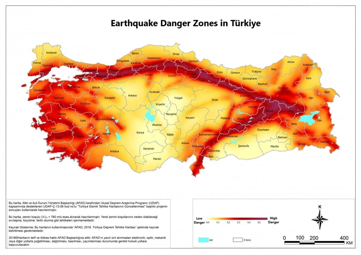
 Türkiye’s official “Earthquake Danger Zones Map,” updated with the efforts of five universities and two state institutions for the first time in 21 years, is expected to be presented to the council of ministers on Jan. 1, 2018. (Mapping by AFAD)
Türkiye is situated in a geologically active region, home to several significant fault lines. Following the devastating earthquakes in Türkiye, public interest surged around the question, “Is there a fault line beneath my home?” This concern has propelled research into Türkiye’s earthquake danger zones and fault line map.
The Disaster and Emergency Management Authority (AFAD) and the General Directorate of Mineral Research and Exploration (MTA) provide information on Türkiye’s earthquake hazard maps and active fault lines.

Updating earthquake danger zones maps
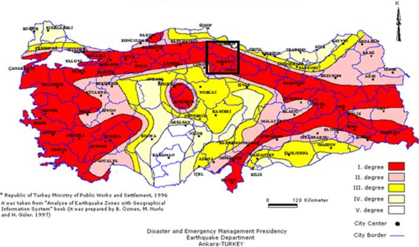
AFAD’s Earthquake Department has recently updated and published the latest version of Türkiye’s Earthquake Danger Zones Map, which was first created in 1996.
This new map, published in the Official Gazette on March 18, 2018, became effective on Jan. 1, 2019, and was supported by the National Earthquake Research Program (UDAP) and the Natural Disaster Insurance Institution (DASK).
Checking for fault lines under your home
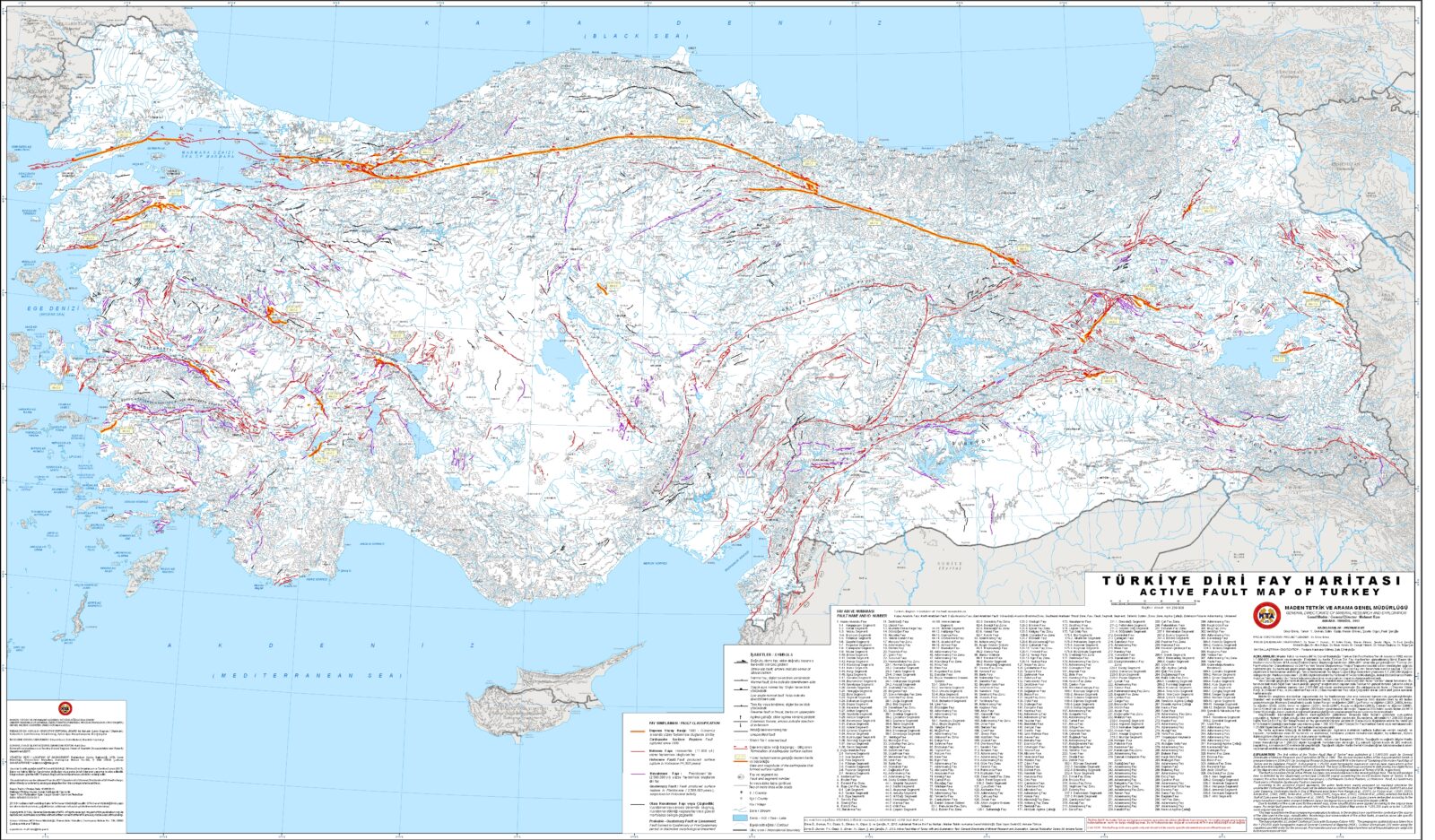
The MTA has recently updated and released the active fault lines map for public access. This map highlights 45 provinces and 110 districts at risk from active faults. It features a total of 485 active fault lines.
Residents can determine whether a fault line runs beneath or near their property by visiting MTA’s official website. To check the seismic risk and fault lines in your area, access the e-Government system and view the “Earthquake Map Inquiry” page.

Major fault lines in Türkiye
North Anatolian fault line (NAF)
The North Anatolian Fault Line is the most active and well-known fault in Türkiye. It begins in the Eastern Black Sea region and stretches westward through North Anatolia, ultimately terminating in the Aegean Sea. This fault has been responsible for many significant earthquakes throughout history.
East Anatolian fault line (EAF)
Located in the Eastern Anatolia Region, this fault line is not as active as the NAF but still exhibits considerable seismic activity.
Western Anatolian fault line
This fault line, found in the Aegean Sea and Western Anatolia, particularly contributes to seismic activity in the Aegean Region.
Cankiri fault line
Situated in Central Anatolia, this fault line can lead to significant regional seismic events.
Understanding active fault lines
Active faults are defined as those that have produced earthquakes in historical periods. The tectonic movements of the plates that make up the Earth’s crust cause strain and compression, accumulating energy in certain regions over centuries. This energy is occasionally released, resulting in earthquakes.
Path of EAF
EAF extends along the boundary between the Anatolian and Arabian plates. The Bitlis-Zagros Fault, located at the Iran-Iraq border and part of the African tectonic plate, exerts pressure on eastern Türkiye, leading to a subduction zone. Consequently, the East Anatolian region rises several millimeters each year.
This fault begins at the northern tip of the Dead Sea Rift, known as the Maras triple junction, and ends at the Karliova triple junction, where it meets NAF.
Path of NAF
NAF is one of the fastest-moving and most active strike-slip faults in the world. Stretching approximately 1,100 kilometers (683.5 miles), it runs from Lake Van to the Saros Gulf and comprises multiple segments, forming a fault zone rather than a single fault line. Starting from the Saros Gulf, the NAF traverses through the Sea of Marmara, Lake Sapanca, Adapazari, Tosya and Erzincan, extending to the northern shore of Lake Van.
According to information from AFAD, 24 provinces are directly crossed by active faults, with more than 80 districts also located on these fault lines. These provinces include Aksaray, Aydin, Balikesir, Bingol, Bolu, Burdur, Bursa, Denizli, Erzincan, Erzurum, Eskisehir, Hakkari, Hatay, Izmir, Kahramanmaras, Kayseri, Kocaeli, Konya, Kutahya, Manisa, Mugla, Osmaniye, Sakarya and Tokat.
Significant earthquakes have occurred along this fault zone, including those in Erzincan (1992), Erzurum (1983), Varto (1966), and the devastating Izmit, Duzce, and Adapazari earthquakes in 1999.
Path of WAF
WAF consists of numerous faults aligned east-west in western Anatolia. While the EAF and NAF experience lateral displacements, WAF predominantly features normal faults, contributing to the expansion of the Aegean Sea. Although the NAF is considered the most hazardous fault line in Türkiye, the WAF is the most active.
As Türkiye grapples with the implications of seismic risks, understanding fault lines is crucial for public safety and preparedness. Residents are encouraged to utilize available resources to assess their earthquake risk and stay informed about developments in Türkiye’s seismic landscape.


