Türkiye publishes first study on maritime borders amid tension with Greece
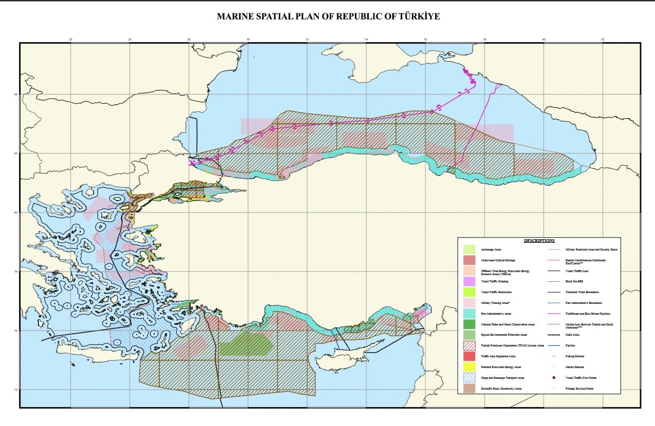 Türkiye's marine spatial planning (MSP) map, accessed on 17 April, 2025. (Photo via Ankara University National Center for the Sea and Maritime Law)
Türkiye has released its first academic study on Marine Spatial Planning (MSP), a key step in organizing maritime space for sustainable use and national interest, according to Ankara University’s National Research Center for Maritime Law (DEHUKAM).
The study, years in the making, marks a significant milestone in Türkiye’s efforts to utilize its surrounding seas in alignment with economic, environmental, and strategic goals.
Marine Spatial Planning Map now publicly available
As part of the initiative, DEHUKAM launched a digital MSP map. The map highlights zones beyond Türkiye’s territorial waters, designated for economic, scientific, and military purposes.
DEHUKAM researchers clarified that the map, while based on scientific data and open-source inputs, does not reflect official state policy or maritime jurisdiction. However, a parallel map is being prepared for submission to the United Nations.
Blue Homeland and strategic coordination
The study supports Türkiye’s “Blue Homeland” doctrine, promoting a comprehensive maritime strategy. To enhance institutional governance, a new “Inter-Institutional Coordination Committee” under the presidency and foreign ministry is being established.
The Turkish Republic of Northern Cyprus (TRNC) is also conducting similar MSP studies.
Sustainable development goals and marine use
According to DEHUKAM, the MSP map will aid in the structured planning of maritime activities, balancing marine ecosystem preservation with economic needs. The plan supports energy, fisheries, transportation, and marine research initiatives.
“Seas are essential for economic development, food security, and ecosystem health,” DEHUKAM stated. “Effective governance through MSP is key.”
MSP is designed as a participatory, science-based process to balance uses, such as
- Fisheries
- Offshore energy
- Maritime transport
- Tourism
- Conservation
- Scientific research
Türkiye’s growing academic and legal engagement
Although Türkiye is not an EU member, the study aligns with EU marine directives. DEHUKAM emphasized that Türkiye is pursuing MSP on its terms, based on sovereignty and ecosystem-based planning.
The Türkiye MSP Platform, coordinated by DEHUKAM, compiles ongoing projects, legal frameworks, and stakeholder data related to MSP.
Statement from DEHUKAM CEO Mustafa Baskara
“The seas face increasing pressures that threaten sustainability, ecosystems, and biodiversity,” said DEHUKAM CEO Mustafa Baskara. “That’s why UNESCO launched MSP efforts in the 2000s through the Intergovernmental Oceanographic Commission.”
“Our work in this field is based on academic data and developed in cooperation with public institutions,” he added. “Through this MSP map and integration with the blue economy, Türkiye’s maritime sectors will expand into new dimensions.”
Baskara described the map as a “living document” that will evolve with future marine planning needs and discoveries.
Dispute with Greece over maritime maps
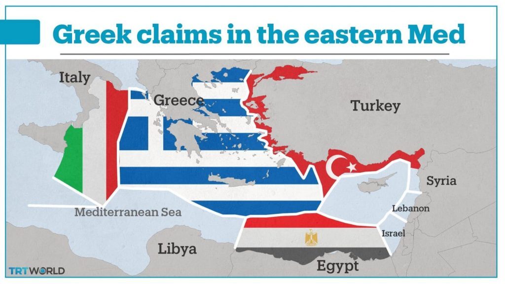
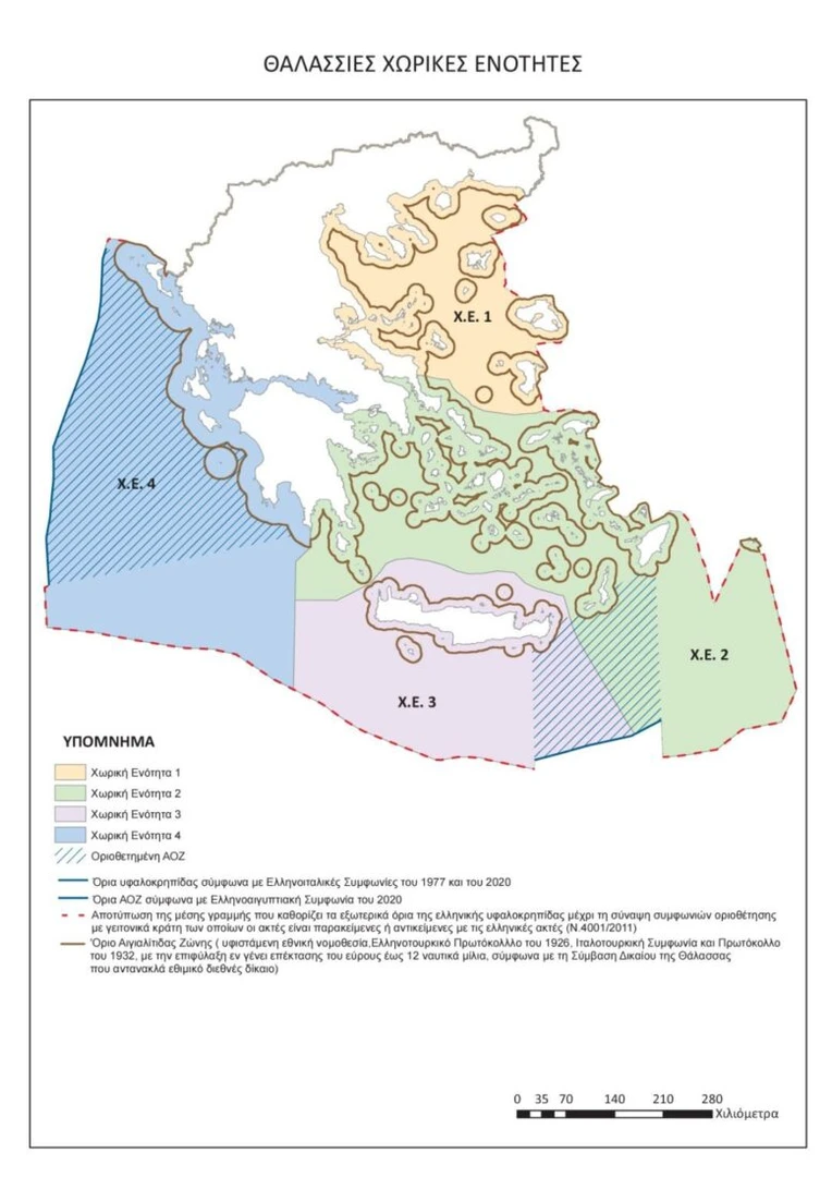
The release follows Greece’s announcement of its official MSP map, which includes disputed areas in the Aegean and Eastern Mediterranean, such as around Meis Island.
The Turkish Foreign Ministry responded that “unilateral actions and faits accomplis will continue to produce no legal effect for our country, as was the case in the past.”
Some of the areas specified in the “Maritime Spatial Plan” (MSP) declared by Greece within the framework of EU legislation violate Türkiye’s maritime jurisdiction areas in both the Aegean Sea and the Eastern Mediterranean.
We reiterate that Greece’s unilateral actions and claims will not have any legal consequences for Türkiye.
We also recall that unilateral actions should be avoided in a closed or semi-closed sea such as the Aegean and the Mediterranean, that international maritime law encourages cooperation between coastal states in these seas, including on environmental issues, and in this regard, Türkiye is always ready to cooperate with Greece in the Aegean Sea.
The aforementioned actions and fait accompli attempts, as in the past, will not have any legal consequences for Türkiye today or in the future.
Türkiye maintains its position that a sincere and comprehensive approach should be adopted to resolve issues on the basis of international law, equity and good neighborliness within the framework of the Athens Declaration on Friendly Relations and Good Neighborliness, dated 7 December 2023, which reflects the spirit that both parties want to uphold in Turkish-Greek relations.
Türkiye will submit its own MSP to UNESCO and the relevant bodies of the United Nations.
Turkish Foreign Ministry
Greece’s Minister of Environment and Energy Stavros Papastavrou commented on the MSP map of Athens and stated, “The Maritime Spatial Planning reflects human activity in the maritime zones of our country—fish farming, fishing, maritime transport, tourism, exploitation of energy resources, etc.—but always with environmental protection and sustainable development in mind.
For the first time, the Greek State comes and delimits detailed uses for the maritime zones throughout its jurisdiction, within the framework of our European commitments and always based on international law and the law of the sea.”
Greece, meanwhile, emphasized that its MSP complies with the EU’s 2014/89 directive and reflects its maritime jurisdiction, stating, “For the first time, our country sets the rules for the organization of maritime space.”
Ankara remains firm that the Greek map is based on maximalist claims and does not acknowledge Türkiye’s continental shelf rights.


